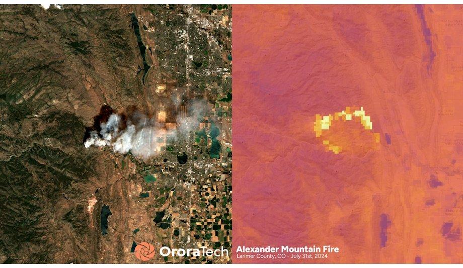
The Larimer County Sheriff's Office has collaborated with OroraTech USA, a leader in space-based wildfire intelligence, to enhance wildfire readiness and emergency response in this high-risk area of Colorado. This partnership integrates OroraTech’s Wildfire Solution into the county’s operations under a 2025 pilot program, offering crucial insights and near-instant alerts tailored for Larimer’s demanding mountainous regions and varied population zones.
OroraTech’s Satellite Wildfire Detection Platform
OroraTech's platform is designed to facilitate early wildfire detection, accelerated situational evaluations, and precise fire spread predictions within the first critical 24 hours of an incident. "Larimer County continues to face rising wildfire frequency and severity. OroraTech provides us with a new layer of intelligence to act faster and smarter," said Justin Whitesell, Chief of Emergency Services for the Larimer County Sheriff’s Office.
Adoption of OroraTech’s Platform in Larimer County
Whitesell emphasized the platform's importance, noting, "Their platform helps us to verify ignition points, model fire spread, and make better decisions with our firefighting resources. It’s quickly becoming a vital addition to our toolkit." With more than 15% of Larimer County’s land burned over recent decades, it stands among the most wildfire-prone regions in Colorado.
High Wildfire Frequency in Larimer County
The county has battled at least 16 major wildfires between 1984 and 2021, including the massive 208,000-acre Cameron Peak Fire in 2020 and the 87,000-acre High Park Fire in 2012. The rugged terrain, dense forests, and expanding population exacerbate its vulnerability to such disasters. “Wildfires are the most frequent natural hazard in Larimer County, and our goal is to ensure agencies have the best possible intelligence at their fingertips,” stated Thomas Grübler, CEO of OroraTech USA.
Satellite Imagery and AI-Enhanced Modeling
OroraTech’s Wildfire Solution integrates satellite imagery with AI-enhanced modeling, empowering emergency teams to quickly identify new ignitions, monitor fire dynamics, and allocate resources efficiently. The system is pivotal in offering actionable data in challenging environments, even during low-visibility scenarios. As wildfires increasingly threaten the American West, Larimer County's adoption of advanced satellite technology underscores its pivotal role in local emergency response strategies.
The Larimer County Sheriff’s Office has partnered with OroraTech USA, the global pioneer in space-based wildfire intelligence, marking a significant step in enhancing wildfire preparedness and emergency response across one of Colorado’s most fire-prone counties.
Under a 2025 pilot program, the Larimer County Sheriff’s Office Emergency Services Division has integrated OroraTech’s Wildfire Solution platform into its operational workflow. The service delivers near-instant wildfire alerts, AI-powered fire spread modeling, and critical insights tailored to Larimer’s mountainous terrain and diverse population zones.
OroraTech’s Satellite Wildfire Detection Platform
The platform supports early identification of wildfire outbreaks, faster situational assessments
The platform supports early identification of wildfire outbreaks, faster situational assessments, and the ability to predict fire spread during the first 24 hours of an incident.
“Larimer County continues to face rising wildfire frequency and severity. OroraTech provides us with a new layer of intelligence to act faster and smarter,” said Justin Whitesell, Chief of Emergency Services for the Larimer County Sheriff’s Office.
Larimer County adopts OroraTech’s Platform
Justin Whitesell adds, “Their platform helps us to verify ignition points, model fire spread, and make better decisions with our firefighting resources. It’s quickly becoming a vital addition to our toolkit.”
Larimer County is consistently ranked among the most wildfire-prone regions in Colorado, with more than 15% of its land area burned in recent decades.
Between 1984 and 2021, the county experienced at least 16 major wildfires, including the 208,000-acre Cameron Peak Fire in 2020 - the largest in Colorado history - and the 87,000-acre High Park Fire in 2012.
High frequency of wildfires in Larimer County
The county's mix of rugged terrain, dense forests makes it one of the hardest-hit jurisdictions
The county's mix of rugged terrain, dense forests, and expanding population centers makes it one of the hardest-hit and highest-risk jurisdictions in the state.
“Wildfires are the most frequent natural hazard in Larimer County, and our goal is to ensure agencies have the best possible intelligence at their fingertips,” said Thomas Grübler, CEO of OroraTech USA.
He adds, “We are proud to support Chief Whitesell, Sheriff John Feyen, and the LCSO team in safeguarding lives, infrastructure, and ecosystems.”
Satellite imagery with AI-enhanced fire spread modeling
OroraTech’s Wildfire Solution combines satellite imagery with AI-enhanced fire spread modeling, offering emergency teams the ability to detect new ignitions, track fire movement, and prioritize response in minutes, not hours.
The system delivers actionable data even in rugged terrain and low-visibility conditions, ensuring situational awareness when it matters most.
As wildfire risk intensifies across the American West, Larimer County’s early adoption of satellite-based wildfire intelligence underscores the critical role that advanced space technology plays in local emergency management.